Snow for Chicago and Downstate 02/12/20

This is basically a dump from our Departmental Slack channel… Nice compact system shaping up for the next 24-48 hours. Normally this would not get my attention but we have been so starved for snow and real winter weather this year I’ll take anything. NAMUS_prec_prec_012
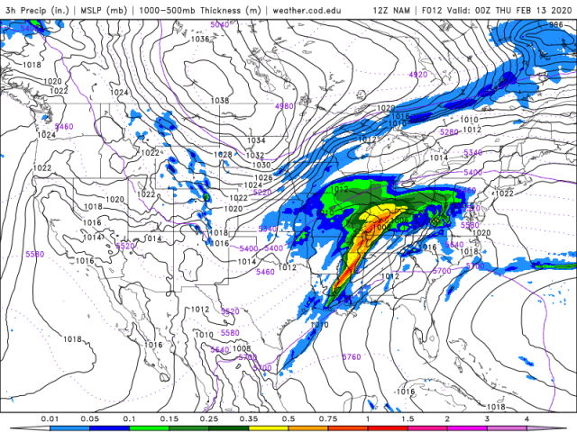
Very interesting MSLP as shown in Figure 1 from the NAM (12Hr FCST). Juicy intense cold front over the Appalachians with copious moisture being fed in (SPC has a SLGHT chance for Severe.. Worried about flooding) Note the solid block high over central Canada and then a second trough squeezed on in over our region. Second figure shows the 500hPa winds.NAMUS_500_spd_012 VERY VERY broad jet dipping down. Chicago is sitting under, kind of the left entrance to the NE propagating jet streak. Take a read of this primer on the impact of jets on instability. The left entrance is a region of unstable air and will be enhancing snowfall over our region… Kind of… Screen Shot 2020-02-12 at 8.57.12 AM

Next figure is a forecast sounding taken at the time of maximum snowfall rate, as forecast by NAM, at +12hours, or at around 6pm Chicago time. Green line is the dewpoint or “water content” while red is temperature. Where the red and green lines are close the atmosphere is saturation and clouds can form. Note the temperature axis is skewed (This is called a SkewT Log P chart) so from 1500m to ~4000m the saturated atmosphere is around 10 degrees celsius… This is borderline temperature for nice snow formation (aka the Dendritic growth zone, DGZ). the DGZ is a range of temperatures at which the saturation vapor pressure for air over ice is much less than that for air over water. This allows a process called WegenerBergeronFindeisen where, basically, ice can very effectively suck all the moisture not only from the atmosphere but surrounding drops.. Suffice to say, when you look at a plot like the above and you are looking to forecast snow, look for deep saturated layers at ~-10 to -15c. Also note the steep lapse rate (decrease in temperature with height) from the surface to ~1km… This layer is what we call “Conditionally unstable” which could allow convective clouds to form… This time is right at the change over from mixed precipitation to snow.. So our total accumulation in Chicago will depend on the exact timing.. Expect a NASTY WET SNOW at the peak commute home 🙂

12Z-20200212_NAMNSTMW_prec_snow-1-30-10-100

Finally, let’s look at the actual NAM (the 4km “Nest”) forecast above… Hopefully you have gathered from my discussion that model estimates for snow  are very uncertain. But if the model (simulation initialized with atmospheric observations) is to be believed we could be shoveling 4 wet inches of snow.. But, wait… There is a kicker here.

13Z-20200212_HRRRCHI_prec_radar-0-18-10-100

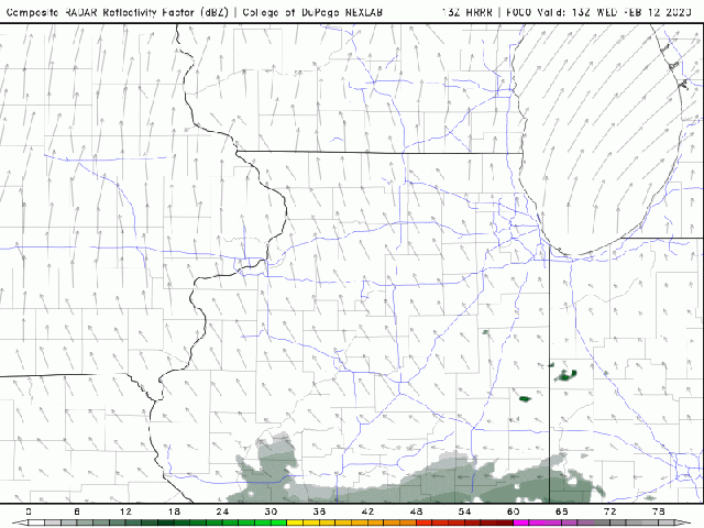
The above animation is from NOAA’s High Resolution Rapid Refresh simulation which is a type of simulation (Model) that we call “Convection permitting”. This means it is high enough resolution to resolve smaller storm systems. But, as it is costly to run it only simulates 18 hours in the future. Note the interesting small features at the end of the predicted radar image. This is a small mesoscale (~100km in size) snow squall.. Behind the squall the winds are turning north east, or off the lake and on to the western shore of lake Michigan. This means we may see some lake enhancement at the end of the event. My take is that we could see 4-7 inches from this event depending on 1) How long we get rain before the snow and 2) If we get some lake enhancement at the end…

m54

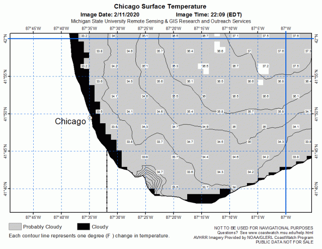
The final image is from Michigan State University and NOAA and shows lake temperatures near Chicago. Just above freezing… So there may be a sweet spot for snow accumulations  ~5km inland from the lake edge… it will be touch and go in the city to begin with.

Weather plots courtesy of the amazing COD NEXLAB site!


More updates… Coming soon.

Whenever I have the best things to share I am at my busiest.. And I don’t post.. Life has been good and busy. Some very exciting things are happening like NSF giving us 9M for Sage. And a chance I can get into active storm tracking (it’s so cool when you hear folks are as excited about a subject as you..). More updates coming soon.. Open source, radar, science, cycling and.. A SKI TRIP TO WHISTLER! Bring it. IMG_4503

It’s Wet. And The Lakes Are Full of Water.

WTTW Chicago tonight gave me a yell asking about the record lake levels. I have been watching the evolving large scale forcing behind the recent rains.

IMG_3414
Irene and Vidya (SAVEUR Scientists) pouring over a map of Chicago identifying key areas to study in Chicago

It is nice as my work on the NSF funded SAVEUR project (Collaboration between Argonne, Northwestern and the University of IL) gives me a little freedom to do this given our focus on Chicago and the region.  In a nutshell: It’s complicated. This time of year we are not particularly strongly impacted by ENSO (Weak but persistent El-Nino) or NAO. But it has rained. A LOT. Chicago beat its all time may record with 8.25 inches (sorry about the old money) of rain.. This is over double its mean rainfall of 3.68 inches. Furthermore the rain has come from a series of torrential persistent (organized) downpours. This has allowed the soil column to becomes so wet it looses the ability to soak, store and evaporate the rain leading to increased run off.

gl_12-the-20gl-20drainage-20basin-20picture
Map of Great Lakes watersheds from Environment Canada

“But wait!” I hear the hydrologists amongst you exclaim, “Only a fraction of the Chicagoland region is in the Great Lakes watershed”. Well you are correct random hydrologist! The figure to the left (from Environment Canada) shows the watersheds of the great lakes. However, take a look at this site from NOAA which shows almost every area around the lakes has received much greater than average rainfall. Furthermore, it has been cold and damp and the lakes themselves have been cold thus inhibiting evaporation. The lake levels (or more so the rate of rise of the lake levels) is the solution to a simple budget equation: The rate of rise (or fall) is water in (Rainfall and diversions from some watersheds in) minus water out (flow into Atlantic via the St Lawrence River plus water lost from diversions away from the lakes plus evaporation). Each of the terms on both sides of this equation involve very complex physics and geopolitics. For example did you know that far less water is diverted away from the lake in Chicago (to the Mississippi) than is added to the lake on the Canadian side? But there is a hard limit to how much extra flow can be added at each point (to the great relief of those living in Montreal). So with well above average rainfall, very wet soils (see this calculation from NOAA with runoff around the lakes at the 95+ percentile) limited evaporation an already modestly full lake system is now breaking records.

Climate Differences

img_2640
-11F in Utqiagvik

What a difference a few months makes. Back in January I was visiting Utqiagvik as a guest of Argonne’s Education and Outreach team. When we arrived it was -20F and lets just assume the dewpoint was -20F. img_3192Today I went for a run in Nanjing, China with a (5am) temperature of 70F and a dewpoint of 65F. In China each kg (roughly a cubic meter has 13.37 grams of water in the form of vapor. In Utqiagvik it was a mere 0.35g. From the dry to the dripping wet!

Behind The Scenes At WTTW

IMG_2805
Isabelle (my Daughter, 14) looking down on the Chicago Tonight studio at WTTW.

Those that have been following will know that the coincidence between my trip to Utqiagvik (which I have been mangling the pronunciation of) this blog and the cold conditions in Chicago led to some media attention. I did a very enjoyable interview on WBEZ’s Morning Edition on Tuesday. A producer at WTTW’s Chicago Tonight listened to that story and invited me on that show. Now, I have actually done a fair bit of radio over the past few years so I was well prepared and not nervous. I have also done pre-recorded TV thanks to growing up in a family well accustomed to the camera (my Dad was a Journalist, now retired) and I had the abject honor to participate in the Alan Alder Science Communications course (and me the legend himself).

nEPMnBdKSY6ck2VSRXiHig
This mug is made for radio.. Lucky I had Yarrow Axford to balance out the picture.

I am not going to lie: I was nervous. I am struggling right now to find a comparison, perhaps at the beginning of the Sub 5 100 mile ride I did a few years ago (which ended up being a wonderful success). I also had some key messages I wanted to get out. I needed to let folks know I was traveling with the Argonne Education team but I had to tread a fine line as the research involves kids and I could not talk about to many details.. So lots of work building some pitch perfect sound bites and then committing them to memory! How? Well, Louise, my wife and wonderful sounding board, would ask me “Why were you in Utqiagvik?” allowing me to have 10+ goes at trying different intonations of the line. I chatted with a fellow atmospheric scientist on Facebook, Victor Gensini, who reassured me that you could not find a more friendly forum than Chicago Tonight for a first foray into live TV. He was right. The team there at WTTW studios were professional, friendly warm and welcoming. Isabelle and Louise came with me to the studio and we had the privilege of rubbing shoulders with state legislators, public advocates and leaders in the City we have adopted as our own: Chicago. I was to appear next to Northwestern Paleo Climate Scientist Yarrow Axford.

KTMZyxvVR%Ctb1TB5VaplA
The team at WTTW do a great job of making us look good!

I felt bad I did not know of her work given my appointment at NAISE. And I should have, she has done brilliant work looking at the geological record for evidence of past climate. Yarrow an I went to makeup (yes.. Makeup!! Another first) and then a lighting and framing check.. Ok, now I was NERVOUS! After that we left the studio and waited to be called. About 5 minutes into the show we went into the waiting area just off camera while a spokesperson from the ALCU was talking about the Chicago PD consent decree. She finished her interview with Paris Schutz and the cut to Brandis Friedman and Amanda Vinicky. Yarrow and I headed out to the interview desk to be wired up for sound while Amanda and Brandis did their bits. I could see the countdown for the return to Paris sitting across from us (Paris could not have been more friendly or supportive!) and all I could think is “I hope I can speak once we start! Don’t choke!”. Fortunately, the format they use on Chicago Tonight is just perfect, you sit across from the host and make eye contact with them and answer clear questions. No looking into a camera and a real human to talk to. This allowed me to ease into a dialogue  and, due to the ease Yarrow and I found on meeting, a conversation between the three of us. It all went really well. Only real flub was I found out I had been mispronouncing Utqiagvik the whole time and the locals had just been too friendly to tell me. I would like to thank Meridith Bruozas of Argonne Education who masterminded the trip, Chris Kramer of Argonne Communications who made sure everything was done right with DOE and helped me prep, Jay, Nicole and Paris at WTTW who were just plain nice and the folks of Utqiagvik who were just inspiring. The interview can be found here. Ok.. Back to normal right?? I’ve got some serious coding to catch up on!